by
by Devastating flash floods swept through Central Texas on July 4, leaving a tragic toll in their wake. At least 120 people have been confirmed dead, including over two dozen children and counselors at Camp Mystic, a Christian summer camp for girls located along the Guadalupe River in Kerr County.
With more than 160 individuals still missing, state officials and rescue teams are working tirelessly to locate survivors and assess the damage. The disaster has become one of the deadliest flooding events in Texas history, impacting multiple counties and raising urgent concerns about flood preparedness in the region.
Key Details:

- Death Toll: At least 120 people have died in Central Texas flooding on July 4, including 27 campers and counselors at Camp Mystic.
- Missing Persons: More than 160 remain unaccounted for, according to Texas Governor Greg Abbott.
- Rescue Efforts: Ongoing as search teams continue to comb the region.
Flood Epicenter: Texas Hill Country
- Kerr County bore the brunt of the floods, with at least 95 fatalities.
- Other affected counties include:
- Travis County (Austin)
- Kendall County
- Burnet County
- Williamson County
- Tom Green County
Camp Mystic Tragedy
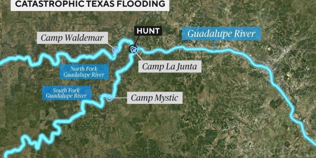
- Located in Hunt, Texas — part of Kerr County.
- Sits directly on the banks of the Guadalupe River, which rose rapidly due to heavy rainfall.
- About 550 children were present during the flooding, per a June 2 inspection report.
- 27 lives lost at the camp alone.
Other Camps Affected
- Camp La Junta and Camp Waldemar, also along the Guadalupe River, confirmed all campers and staff are safe.
- At Camp La Junta, two brothers, Braeden and Brock Davis, were among those who escaped safely.
Weather Conditions


- Torrential rain saturated the Texas Hill Country, causing flash floods and rapid river rises early on July 4.
- National Weather Service data confirmed critical water levels in the Guadalupe River.
Impact Summary:
- Kerrville, the largest city in Kerr County, is about 100 miles west of Austin and 65 miles northwest of San Antonio.
- The flooding is among the deadliest weather events in recent Texas history.
- Officials continue to urge caution and cooperation with rescue operations and emergency protocols.