 by
by Another warm front cold front combination is heading eastward from a storm system now moving out of the Central Plains and into the Great Lakes.
The cold front from this system will be approaching late Thursday into early Friday and that front will bring the risk for thunderstorms.
The Storm Prediction Center has indicated an area of marginal risk for severe weather which means isolated severe thunderstorms are possible for much of Eastern Pennsylvania to Southern New England including all of New Jersey, the Hudson Valley & Long Island. This will also come with an elevated risk for tornadoes.

Ahead of the warm front today we will see sunshine give way to increasing clouds. Winds from the southeast today will keep temperatures mostly in check. Highs will be mostly in the upper 40s north of NYC and Northern New Jersey and low and middle 50s South Jersey and points south.
The warm front will bring an area of showers that will pass mostly to the north late today and into tonight. We will include the chance for some scattered showers north of NYC into the Hudson Valley & New England. Temperatures overnight will probably hold firm in the 40s and lower 50s.
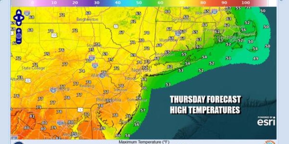
Any overnight showers should be mostly gone by Thursday morning and winds will turn southwest. That will allow warmer temperatures to push northward.
Clouds will give way to some sunshine in the warm sector though it will be more successful to the south verses areas north and east of NYC. Highs will reach the upper 60s to middle 70s from north to south and it will be cooler along south and east facing shorelines.

This storm system heading for the Great Lakes today will head into Southeastern Canada. The cold front will push southward from the northwest Thursday night into Friday morning and it is in this time frame that we see the chance for some thunderstorms.
Isolated severe thunderstorms are possible as the front passes through Friday morning.There should be improving weather conditions Friday afternoon with clouds giving way to some sunshine.
Highs will be mostly in the low to mid 60s. Weather models are showing another a couple of weather systems over the weekend with another warm front cold front situation Saturday that could bring clouds and some rain and then a cold front late Sunday into Monday that could bring showers and some thunderstorms once again.