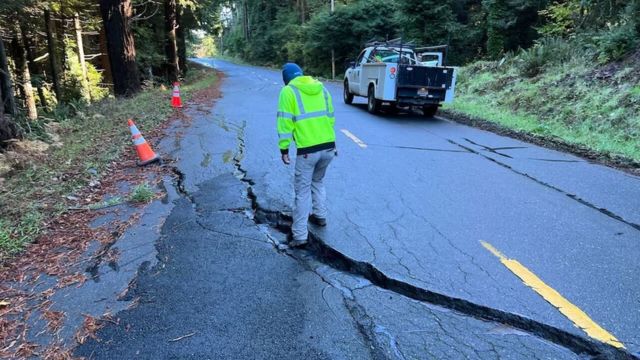
A tsunami warning was briefly issued for the coasts of northern California and southern Oregon on Thursday morning after an earthquake erupted off the coast of California.
According to the U.S. Geological Survey, the magnitude 7.0 earthquake struck at approximately 10:44 a.m., 62 miles west of Ferndale, California.
The coast between Davenport, California, and the Oregon border between Douglas and Lane counties was under a tsunami warning. Around 11:55 a.m., the Tsunami alert Center canceled the alert.
Michelle Bushnell, the district 2 supervisor for Humboldt County, the community on territory nearest the epicenter, reported no fatalities or injuries. However, she claimed to have heard of houses that had been pulled off their foundations, damaged windows, and broken water mains.
According to state senator Mike McGuire, almost 10,000 individuals in Humboldt County were without electricity.
With the majority of the seismic activity centered around Humboldt County, the 7.0-magnitude earthquake was one of at least 17 that shook Northern California on Thursday.
There were at least four documented events in the Ferndale region, and there was also a lot of activity near Petrolia, where at least ten earthquakes with magnitudes ranging from 3.1 to 4.2 occurred.
In order to aid in the response, California Governor Gavin Newsom informed reporters on Thursday that he has signed an emergency proclamation.
“It’s another reminder of the state that we live in and the state of mind that we need to bring to our day-to-day reality here in the state of California, in terms of being prepared for earthquakes,” Newsom stated.
The 7.0 earthquake began less than a mile below the surface of the Earth, making it unusually shallow, according to Christine Goulet, director of the USGS Earthquake Science Center in Los Angeles. There were almost a dozen aftershocks recorded.
According to Goulet, there is a 5% possibility that an earthquake larger than magnitude 6.0 may occur in the region in the coming week, according to the USGS estimate.
“Following a 7, there could be fairly large aftershocks,” Goulet stated. “As time goes by, they’re going to be less frequent and smaller.”
When the seafloor shifts due to an earthquake, waves may rush toward the coast, generating tsunamis. Based on initial data regarding an earthquake’s location, a tsunami warning signals that substantial floods and inundation are anticipated along the coast.
According to Pacific Northwest Seismic Network director Harold Tobin, the earthquake was a strike-slip earthquake, meaning that two plates slid past one another, creating shaking.
Maryland Weather: Cold continues, strong winds develop Thursday
At the meeting point of the Pacific, North American, and Juan de Fuca plates, the Mendocino fault zone is where the earthquake occurred.
According to Tobin, it was the strongest earthquake to strike the region since the 1990s. therefore did not occur on the Cascadia Subduction Zone, he continued, and therefore was unlikely to raise the likelihood of an earthquake there.


 by
by 


